
Waterbury Address Sources by Era
A backward address search works when each source is asked only what it can prove. Waterbury GIS and eQuality establish the modern parcel and assessor label. The Town Clerk's land index supplies transfer events. Silas Bronson Library directories can place a named person at an address in a stated publication year. Census, newspaper, probate, permit, map, and archival sources then test or explain gaps.
| Record Source | Time Span | Waterbury Keeper | Evidence Found |
|---|---|---|---|
| Land-record index | 1978 to present; historical books, 1960 to 1982 | Town Clerk and SearchIQS | Parties, transfers, book and page |
| City directories | 1868–69 through 1990, nearly complete physically | Silas Bronson Library | Residents, work, firms, and streets |
| Historic maps | 1879, 1896, 1901, 1909, 1917, and 1932 among available sets | Bronson, Library of Congress, city | Old street context, structures, and lots |
| Parcel and sales data | Current card; 2022 revaluation basis | GIS and eQuality | MBL, assessor label, sales, map links |
| Probate and newspapers | Varies by collection and jurisdiction | Probate Court, Bronson, State Library | Estate clues, notices, relatives, context |
For a recent transfer, start with the parcel and deed index. For nineteenth- or twentieth-century past residents, start with a directory year and map. Neither route should turn an undated name into a claim of current presence.
Anchor Waterbury Records to Parcels
Type the number and street into the Waterbury GIS search. Save the Map-Block-Lot number, called the MBL, and unique identifier. The result links assessor facts, building information, values, sales, permits, property maps, and eQuality. These keys are more stable than a name and can survive an ownership change.
The eQuality property card offers owner, location, street, MBL, property-use, condominium, and sales filters. Its sale screen narrows by date, price, parcel features, design, size, and rooms. Those fields form an assessor dataset, not the full deed record. Waterbury assesses at 70 percent of estimated market value, so an assessment is not a sale price or deed consideration.
Evidence flow: address → MBL → assessor label → recorded deed → earlier grantee → earlier grantor.
Walk Waterbury Deeds Backward
The Waterbury Town Clerk directs researchers to the SearchIQS land index. The index reaches from 1978 to the present. Historical books list grantor and grantee coverage from 1960 through 1982. Older or image-missing entries may require the Town Clerk counter, a prepaid phone or email copy request, or a book reference found online.
- Find the modern parcel in GIS. Save its MBL, owner label, and map references.
- Locate that owner's acquisition. Record date, book, page, and both parties.
- Treat the seller as a prior grantee. Find the deed by which that seller acquired the parcel.
- Repeat the link, comparing legal descriptions or map references. A matching surname is weak proof.
- When online coverage ends, take the last sound reference to the Town Clerk or archive.
SearchIQS historical help says to choose Book Type before Book/Page. Some items are index-only. The live account page listed free access and $2 per downloaded or printed image when researched; verify current charges.
- Grantor
- The party conveying an interest.
- Grantee
- The party receiving it. Today's seller was often an earlier grantee.
- Chain of title
- The linked sequence of recorded transfers for one parcel.
- Legal description
- The land description or map reference that identifies property more firmly than a street number.
Waterbury's 1891 Address Reset
A number match can fail before the search reaches a deed. The digitized Town and City of Waterbury records a citywide street renumbering in 1891 under an engineer's plan. A nineteenth-century house number may not map to today's number even when the street name survives.
Preserve the old wording. Entries such as “h Willow c Grand” and “h Willow n W Main” use a house marker, street, cross street, and direction. Compare them with Bronson's map guide and 1879, 1896, 1909, and 1932 materials. A cross street, adjacent firm, or neighboring household may make the match when a number cannot.
Do not publish a guessed conversion. The sound result runs from old number, to cross street, to dated atlas, to modern parcel.
Pair Waterbury Directories and Census
Deeds identify land interests, not all occupants. Silas Bronson Library's Waterbury directory collection begins in 1868–69 and is nearly complete on the physical shelf through 1990. Entries may show name, address, work, widow status, business, or cross street. Missing pages, stale listings, abbreviations, and OCR errors are normal.
- Choose the volume nearest the date and capture the full entry, page, and year.
- Browse street and name sections. Another household member may carry the listing.
- Check volumes before and after to bound arrival, departure, or address change.
- Pair the directory with the closest public census, allowing for its date and 72-year release rule.
- Compare names, ages, kin labels, work, neighbors, and street order without assuming all details are exact.
The collections themselves belong on the Waterbury city directory page. Here they test who lived here before between recorded ownership events.
Waterbury Sales and Building Work
The GIS parcel result opens sales and permit histories, but they describe different events. eQuality sale filters help find likely transactions. GIS permits identify date, number, type, and detail link. Planning applications and code cases have separate columns. A blank table is still a result for that query, not proof that all work was absent.
Permits can explain why a site looks different between map or directory years. They may identify an applicant or owner label at that time, yet that person is not automatically an occupant. Record the MBL and access date, then use the deed index to confirm ownership changes.
Note: Waterbury GIS updates nightly, but the city marks mapping and assessor data as informational rather than certified title evidence.
Map Past Waterbury House Footprints
Historic maps can show that a structure or lot existed before a modern card. The Library of Congress holds 1901 Waterbury Sanborn maps, identified as 66 sheets. Yale lists more Sanborn years, while Bronson points to city atlases and indexed maps. These show footprints, materials, uses, lots, and landmarks.
Maps do not name every occupant. Compare one block on a dated Sanborn, a 1917 city map, and current GIS aerial. If the footprint stays while names change in directories, the sources support building continuity without claiming one household remained.
The Connecticut State Library also holds about 367 Waterbury postcards. A labeled store, school, church, or intersection can anchor a block whose text changed.
Waterbury Probate Closes the Trail
An estate case or obituary may explain why a name vanishes or title moves. The Connecticut Probate lookup accepts case type, district, status, and party names. Modern matters route through Waterbury PD-20, but historic jurisdiction changed. Use the death date and State Library district guide before assuming the modern court holds an early file.
The official Connecticut Probate case search shows the limits of the index before a document request.
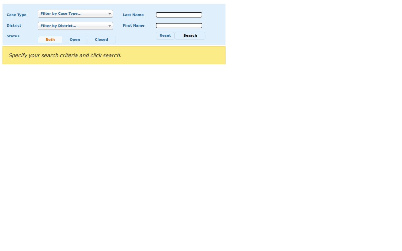
The fields support a focused index query, while confidential documents remain unavailable and a docket summary is not a certified file. Contact the Probate Court at 49 Leavenworth Street or the proper historic repository for records.
Bronson's genealogy desk can help with an obituary when given a name, rough date, and town context. Its microfilm spans several Waterbury papers and fills gaps between directory years.
No New Haven County Recorder
Waterbury is in New Haven County, but Connecticut abolished county government in 1960 and has no county seats. A source tagged “New Haven County” does not point to a county assessor, clerk, or recorder. Modern land records stay with the Waterbury Town Clerk; courts and archives may route through a judicial district or state repository.
For a county clue, set the town and date first. Search Waterbury when the parcel lies here. Use the State Library's New Haven County guide for older court, probate, census, newspaper, or map material.
Label Waterbury Previous Resident Evidence
A deed party, assessor owner, directory occupant, permit applicant, and probate party are different roles. Strong house history keeps those labels and dates. It separates a certified Town Clerk copy from an online index, library scan, finding aid, or OCR lead.
Ask what each match says. A directory places a printed name at an address for its publication period. A deed records a transaction. A parcel card gives an assessor label. None alone proves who was present later.
Lawful use. Research Waterbury previous residents for genealogy, estate work, house history, or personal curiosity. Never use an address trail to watch, harass, threaten, or harm a living person.